Ah, that old cliché, “a picture is worth a thousand words.”
Recently, I came across a photograph of the South Yuba River snapped by NASA’s ASTER (Advanced Spaceborne Thermal Emission and Reflection Radiometer). There are way more than a thousand words embedded in the below photograph. [story continues…]
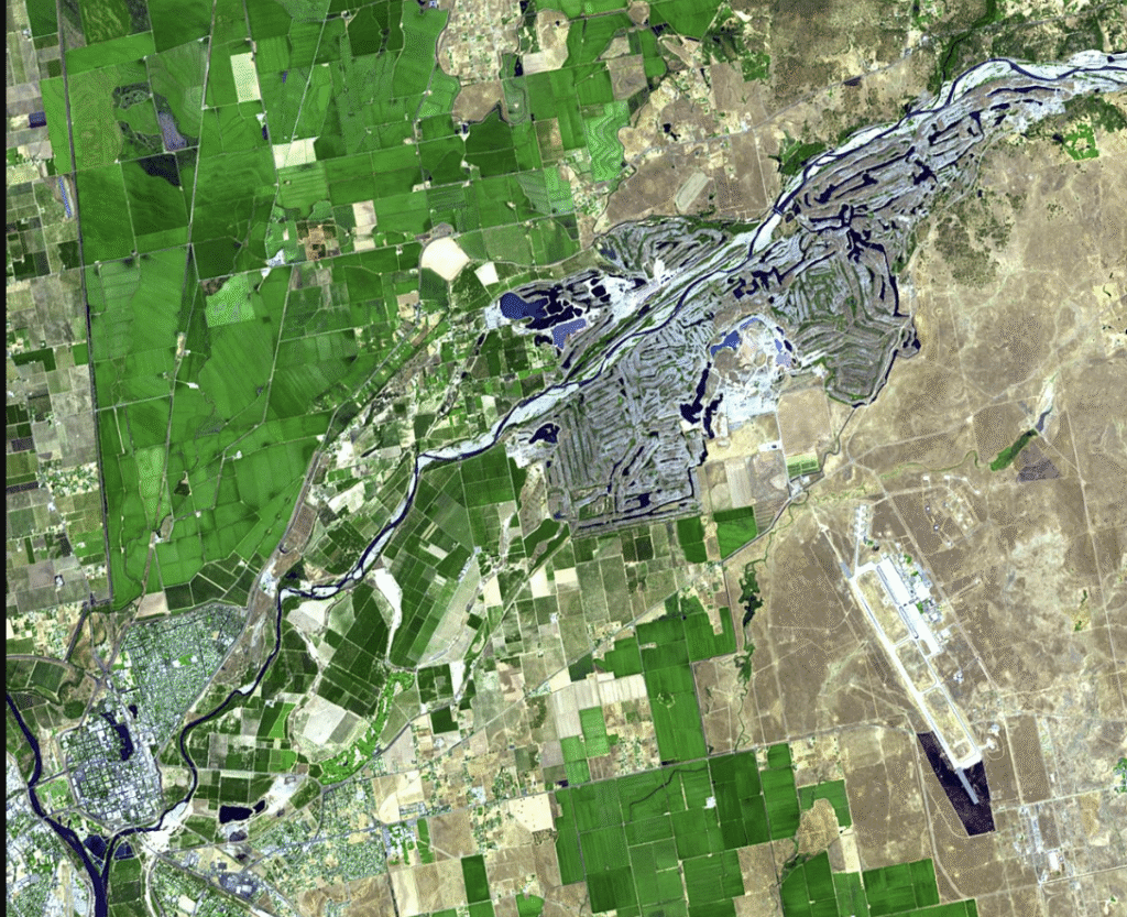
This satellite-rendered image was snapped in 2001, although now over a quarter of a century old, it demonstrates the tortuous history of the South Yuba River. The photo reveals, as one article put it, an “unnatural landscape” looking more like a “bowl of intestines” than a free flow of water descending from the mighty Sierra Nevadas. NASA described the squiggled intestinal image as “long gray shapes” where “hills of gravel [are] interspersed with blue ponds.”
That gravel is part of the trauma humans inflicted upon the Yuba River further upstream. For those who don’t know, after gold was announced in 1849, the Sierra Nevada mountain ranges were inundated by gold seekers, aka, ’49ers. Once the easy pickens were gone, rivers and creeks that tumbled from the mountains bore witness to hydraulic mining. High-pressure water cannons blasted the mountain sides, sending topsoil, rock, and gravel, creating ecological disasters of monumental proportions. It’s estimated that between 1854 and 1883, about 685 million cubic feet of debris were unceremoniously deposited in the Yuba River. Farms just east of Marysville were buried. Local lawsuits, then federal lawsuits, brought and slowed the hydroblasting. In 1884, federal judge Lorenzo Sawyer levied an injunction against the mining industry, which severely curtailed mining companies from dumping its debris in the Yuba River. The Sawyer decision nearly halted hydroblasting. However, a congressman representing Amador County, Anthony Caminetti, worked with the surviving mining companies and crafted legislation to deal with the debris and handed over jurisdiction of the Yuba River to the Army Corps of Engineers. The 1893 Caminiti Act then created the era of dams to catch the silt and relicense minig companies still left if they could prevent further silt from entering the watershed.
The Yuba River was no exception. The 2001 NASA photo, green on one side, brown on the other, demonstrates where the farmland of the great Sacramento Valley meets with the rangy, low foothills of the Sierras. The initial blast of hydro-cannons sent tons of debris downstream, covered farms with “slickens” – a mixture of mud, muck, gravel, and green matter. That hydro-blasting practice lasted from the 1850s till 1884. By then the damage was felt hundreds of miles away. Not only were the farmlands below the river covered in muck by as much as 100 feet in some places, but the City of Sacramento had to raise its I Street Bridge 20 feet as Yuba River sediment traveled into the Sacramento River. Waterways as far as San Francisco had to be dredged. Yuba River sediments had migrated that far.